
Maps Prepared by Simons
Preview
Item Type
Map
Creation Date
1928
Description
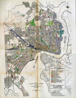
Map of Jacksonville, Florida. Includes a city plan legend for existing and proposed streets, parks, play fields, schools, fire stations, business districts, cemeteries, public properties, railroad and industrial properties, sub-civic centers, incinerator sites, sewage interceptors, and hospitals. [Jacksonville, Fla. : Simons?, 1930?] Included in Comprehensive City Plan of Jacksonville, Supplement 1.
View The Comprehensive City Plan of Jacksonville, FL here: http://digitalcommons.unf.edu/simonsflorida/7/
Keywords
City planning -- Florida -- Jacksonville; George W. Simons Jr.; zoning; city planning