

Preview
Document Type
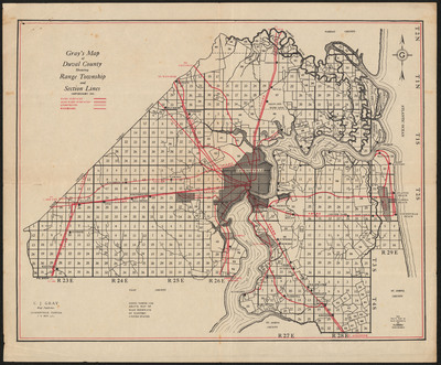
Map
Physical Location
G3934.J2 1925 .C22
Date of Creation
©1925
Publication
Jacksonville, Fla. : C.J. Gray
Language
English
Description
Shows principal towns, railroads and hard surfaced, semi-hard surfaced and unimproved roads. Shows principal towns, railroads, and hard surfaced, semi-hard surfaced and unimproved roads.
Map Scale
Scale not given
alc0121 verso.jpg (9836 kB)
verso
verso
Part of
Allen Lastinger Center for Florida History
Keywords
Early maps; Duval County (Fla) -- Maps

Recommended Citation
C.J. Gray (Firm). "Gray's map of Duval County showing range, township and section lines." Jacksonville, Fla. : C.J. Gray, ©1925. Allen Lastinger Center for Florida History. Thomas G. Carpenter Library, University of North Florida. UNF Digital Commons, https://digitalcommons.unf.edu/alcfh-maps/125