

Preview
Document Type
Map
Physical Location
G3934.S2 1777 .J4
Contributors
William Faden, 1749-1836 {publisher}
Date of Creation
1777
Publication
London : Printed for W. Faden Charing Cross
Language
English
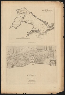
Description
Historical city plan of St. Augustine based on the survey of John de Sólis completed 10 years earlier. Map shows lines of defense, public buildings, houses, streets, fields, gardens and Castillo de San Marcos. Historical chart of Tampa Bay area "according to the Spaniards" named La Bahia de Espiritu Santo by Hernando de Soto.
Map Scale
Scale approximately 1:4,752 ; 660 feet or 1 furlong -- (W 81°18ʹ52ʺ--W 81°18ʹ52ʺ/N 29°53ʹ41ʺ--N 29°53ʹ41ʺ)
verso
Part of
Allen Lastinger Center for Florida History
Keywords
Early maps; Bays -- Florida -- Maps -- Early works to 1800; Saint Augustine (Fla) -- History -- Maps -- Early works to 1800; Castillo de San Marcos (Saint Augustine, Fla.) -- Maps -- Early works to 1800.; Tampa Bay (Fla) -- History -- Maps -- Early works to 1800; Hillsborough Bay (Fla) -- Maps -- Early works to 1800

Recommended Citation
Jefferys, -1771, Thomas. "Plan of the town of St. Augustine, the capital of East Florida ; The Bay of Espiritu Santo, on the western coast of East Florida." London : Printed for W. Faden Charing Cross, 1777. Allen Lastinger Center for Florida History. Thomas G. Carpenter Library, University of North Florida. UNF Digital Commons, https://digitalcommons.unf.edu/alcfh-maps/22