

Preview
Document Type
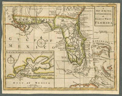
Map
Physical Location
G3930 1763 .G5
Date of Creation
1763
Publication
London : Publisher not identified
Language
English
Description
From the Gentleman's Magazine and Historical Chronicle (November, 1763), vol. 33. Shows indigenous people villages, Fort Mobile, "la Balise Ft., Pensacola," "Old Town," and "New Town," rivers and inlets, anchorages, and soundings.
Map Scale
Scale approximately 1:5,000,000 -- (W 92°02ʹ00ʺ--W 76°01ʹ00ʺ/N 31°32ʹ00ʺ--N 22°44ʹ00ʺ)
verso
Part of
Allen Lastinger Center for Florida History
Keywords
Early maps; Florida -- Maps -- Early works to 1800; Southern States -- Maps -- Early works to 1800; Pensacola Bay (Fla) -- Maps -- Early works to 1800

Recommended Citation
Gibson, active 1750-1792, J. (John). "A map of the new governments of East & West Florida." London : Publisher not identified, 1763. Allen Lastinger Center for Florida History. Thomas G. Carpenter Library, University of North Florida. UNF Digital Commons, https://digitalcommons.unf.edu/alcfh-maps/30