

Preview
Document Type
Map
Physical Location
G4390 1715 .M6
Date of Creation
1715?
Publication
London: Printed for Tho. Bowles in St. Pauls Church Yard and John Bowles at the Black Horse in Cornhill
Language
English
Description
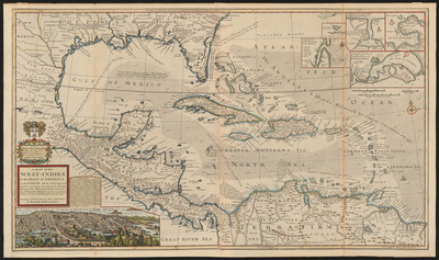
Includes historical notes. Insets: The city of Mexico in New Spain.--A draught of ye citty of Cartagena, its harbour & forts.--[Porta Bella] --A draught of the bay & citty of Havanna.--A draught of St. Augustin and its harbour. Shows southern United States, Mexico, Central America, West Indies, and northern South America.
Map Scale
Scale ca 1:4,300,000 -- (W 101°58ʹ00ʺ--W 55°05ʹ00ʺ/N 33°27ʹ00ʺ--N 4°38ʹ00ʺ)
Part of
Allen Lastinger Center for Florida History
Keywords
Early maps; Caribbean Area -- Maps -- Early works to 1800; West Indies -- Maps -- Early works to 1800; Spanish Main -- Maps -- Early works to 1800; Treasure troves -- Caribbean Area -- Maps -- Early works to 1800; Treasure troves -- West Indies -- Maps -- Early works to 1800; Treasure troves -- Spanish Main -- Maps -- Early works to 1800

Recommended Citation
Moll, -1732, Herman. "A map of the West-Indies or the islands of America in the North Sea; : with ye adjacent countries; explaning sic what belongs to Spain, England, France, Holland &c also ye trade winds, and ye several tracts made by ye galeons and flota from place to place According to ye newest and most exact observations." London: Printed for Tho. Bowles in St. Pauls Church Yard and John Bowles at the Black Horse in Cornhill, 1715? Allen Lastinger Center for Florida History. Thomas G. Carpenter Library, University of North Florida. UNF Digital Commons, https://digitalcommons.unf.edu/alcfh-maps/77