

Preview
Document Type
Map
Physical Location
G3930 1827 .V3
Date of Creation
1827
Publication
Bruxelles : Ph. Vandermaelen
Language
French
Description
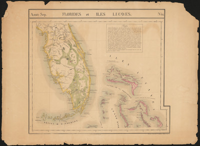
Map of Florida and parts of the Bahama Islands showing early roads or indigenous people trails and several early colonies. Includes northern Florida south from St. Augustine and does not include any of Panhandle area. Includes text: "Florides".
Map Scale
Scale 1:1,641,836 -- (W 83°41ʹ--W 75°10ʹ/N 30°00ʹ--N 24°00ʹ)
Part of
Allen Lastinger Center for Florida History
Keywords
Early maps; Florida -- Maps; Bahamas -- Maps

Recommended Citation
Vandermaelen, 1795-1869, Philippe. "Florides et Iles Lucayes." Bruxelles : Ph. Vandermaelen, 1827. Allen Lastinger Center for Florida History. Thomas G. Carpenter Library, University of North Florida. UNF Digital Commons, https://digitalcommons.unf.edu/alcfh-maps/70
Accessibility Statement
This item was created or digitized before April 24, 2027, or is a reproduction of legacy material created before that date. It is preserved in its original, unmodified state specifically for research, reference, or historical recordkeeping. In accordance with the ADA Title II Final Rule, the Library provides accessible versions of archival materials by request. If you are experiencing difficulty accessing the information on the site due to a disability, please submit a request through the following form for assistance.