

Preview
Document Type
Map
Physical Location
G3860 1755 .S4
Contributors
Mark Catesby, 1683-1749 {creator}
Date of Creation
1755
Publication
Norimbergae : Johann Michael Seligmann
Language
Latin
Description
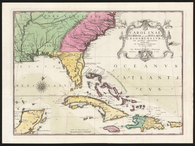
Depicts the Southeast as far west as the Mississippi River. Colored to show the British possessions in pink, the French in green, and the Spanish in yellow.
Map Scale
Scale [ca 1:4,600,000] -- (W 97°00ʹ--W 62°00ʹ/N 37°20ʹ--N 17°00ʹ)
Part of
Allen Lastinger Center for Florida History
Keywords
Early maps; Caribbean Area -- Maps -- Early works to 1800; Southern States -- Maps -- Early works to 1800

Recommended Citation
Seligmann, 1720-1762, Johann Michael. "Carolinae, Floridae nec non Insularum Bahamensium : cum partibus adjacendibus." Norimbergae : Johann Michael Seligmann, 1755. Allen Lastinger Center for Florida History. Thomas G. Carpenter Library, University of North Florida. UNF Digital Commons, https://digitalcommons.unf.edu/alcfh-maps/76
Accessibility Statement
This item was created or digitized before April 24, 2027, or is a reproduction of legacy material created before that date. It is preserved in its original, unmodified state specifically for research, reference, or historical recordkeeping. In accordance with the ADA Title II Final Rule, the Library provides accessible versions of archival materials by request. If you are experiencing difficulty accessing the information on the site due to a disability, please submit a request through the following form for assistance.