

Preview
Document Type
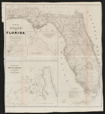
Map
Physical Location
G3930 1846 .S828
Contributors
William A. Whitehead ;Jacob Edmund Blake, 1811 or 1812-1846 ;D. (David) McClelland, 1820-1899
Date of Creation
1846
Publication
Washington : U.S. War Dept.
Language
English
Description
Shows topography and surveyed areas of the state.
Map Scale
Scale 1:550,000 Scales of insets vary
Part of
Allen Lastinger Center for Florida History
Keywords
Early maps; Florida -- Maps; Key West (Fla); Suwannee River (Ga and Fla) -- Maps; Saint Johns River (Fla) -- Maps; Railroads -- Florida -- Maps

Recommended Citation
Bruff, 1804-1889, Joseph Goldsborough. "The state of Florida : Compiled in the Bureau of Topographical Engineers from the best authorities." Washington : U.S. War Dept., 1846. Allen Lastinger Center for Florida History. Thomas G. Carpenter Library, University of North Florida. UNF Digital Commons, https://digitalcommons.unf.edu/alcfh-maps/80
Accessibility Statement
This item was created or digitized before April 24, 2027, or is a reproduction of legacy material created before that date. It is preserved in its original, unmodified state specifically for research, reference, or historical recordkeeping. In accordance with the ADA Title II Final Rule, the Library provides accessible versions of archival materials by request. If you are experiencing difficulty accessing the information on the site due to a disability, please submit a request through the following form for assistance.