

Preview
Creation Date
1-16-2012
Description
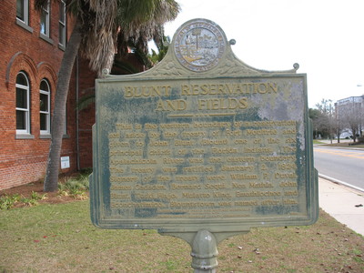
Blunt Reservation and Fields Marker, Blountstown, Fl.
This historical marker is in Blountstown, Florida, on Highway 20. It was placed by Calhoun County Board of County Commissioners in 1964.
It reads as :
" This is the western boundary of a reservation set aside by the treaty of Fort Moultrie and given to John Blunt (Blount) one of the six principal chiefs of the Florida Indians. The Apalachicola River was the eastern boundary. The treaty was ratified January 2, 1824. Signers of the treaty were William P. Duval, James Gadsden, Bernard Sequi, Nea Mathla, John Blunt, Tuski Hajo, Mulatto King, Emathlochee and Econchatimico. Blounstown was named after him."
Latitude, Longitude
30.44331944, -85.04331944
Recommended Citation
Taylor, George Lansing Jr., "Blunt Reservation and Fields Marker, Blountstown, FL" (2012). George Lansing Taylor Collection Main Gallery. 2971.
https://digitalcommons.unf.edu/historical_architecture_main/2971
Rights Statement
http://rightsstatements.org/vocab/InC/1.0/
Keywords
Taylor, George Lansing, Jr.; Lance Taylor; Photographers -- Florida -- Jacksonville; Photograph collections -- Florida -- Jacksonville; Blunt Reservation and Fields marker; Blunt Reservation; John Blunt (Blount) --- Chief of Florida Indians; Historical marker; Calhoun County (Fl.); Blountstown (Fl.); Historical markers --- Florida --- Blountstown.; Images