

Maps Prepared by Simons
Preview
Item Type
Map
Creation Date
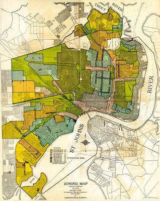
9-9-1930
Description
Zoning map, adopted by ordinance no. U-125, September 9, 1930. In conformity with the comprehensive city plan of Jacksonville, Florida. [Jacksonville, Fla. : Simons?, 1930?] Included in Comprehensive City Plan of Jacksonville, Supplement 1.
View The Comprehensive City Plan of Jacksonville, FL here: http://digitalcommons.unf.edu/simonsflorida/7/
Accessibility Statement
This item was created or digitized before April 24, 2027, or is a reproduction of legacy material created before that date. It is preserved in its original, unmodified state specifically for research, reference, or historical recordkeeping. In accordance with the ADA Title II Final Rule, the Library provides accessible versions of archival materials by request. If you are experiencing difficulty accessing the information on the site due to a disability, please submit a request through the following form for assistance.