

Preview
Creation Date
2-2-2011
Description
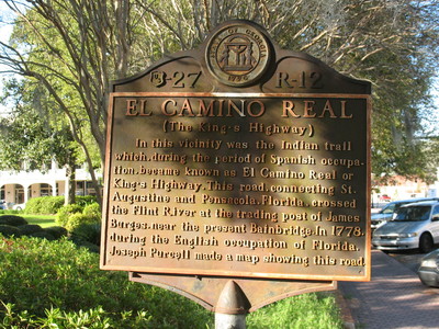
El Camino Real ( The King's Highway) Marker, Bainbridge, GA.
This marker is located at the corner of the Decatur County Courthouse square, in Bainbridge, Georgia. It was sponsored by the U.S. Works Progress Administration Marker.
The text on the marker reads as :
" In this vicinity was the Indian trail which, during the period of Spanish occupation, became known as El Camino Real or King's Highway. This road, connecting St. Augustine and Pensacola, Florida, crossed the Flint River at the trading post of James Burges, near the present Bainbridge. In 1778, during the English occupation of Florida, Joseph Purcell made a map showing this road."
Latitude, Longitude
30.90642222, -84.57567778
Recommended Citation
George Lansing Taylor, Jr. "El Camino Real (The King's Highway) Marker, Bainbridge, GA." (2011). Image Collection. University of North Florida, Thomas G. Carpenter Library Special Collections and Archives. UNF Digital Commons, https://digitalcommons.unf.edu/historical_architecture_main/3077/
Image Location

Accessibility Statement
This item was created or digitized before April 24, 2027, or is a reproduction of legacy material created before that date. It is preserved in its original, unmodified state specifically for research, reference, or historical recordkeeping. In accordance with the ADA Title II Final Rule, the Library provides accessible versions of archival materials by request. If you are experiencing difficulty accessing the information on the site due to a disability, please submit a request through the following form for assistance.