

Preview
Creation Date
2-18-2012
Description
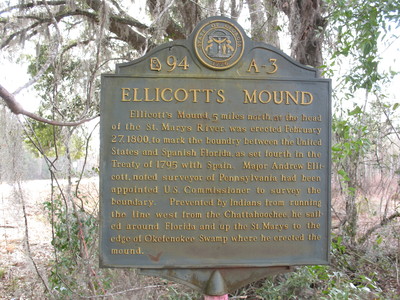
Ellicotts Mound Marker, Moniac, GA.
This marker is located on Ellicotts Mound , 5 miles north at the head of the St Marys River.
The text on the marker reads as :
" Ellicott`s Mound, 5 miles north, at the head of the St. Marys River, was erected February 27, 1800, to mark the boundary between the United States and Spanish Florida, as set fourth in the Treaty of 1795 with Spain. Major Andrew Ellicott noted surveyor of Pennsylvania had been appointed U.S. Commissioner to survey the boundary. Prevented by Indians from running the line west from the Chattahoochee, he sailed around Florida and up the St. Marys to the edge of Okefenokee Swamp where he erected the mound. "
Latitude, Longitude
30.51820000, -82.22780000
Recommended Citation
George Lansing Taylor, Jr. "Ellicotts Mound Marker, Moniac, GA." (2012). Image Collection. University of North Florida, Thomas G. Carpenter Library Special Collections and Archives. UNF Digital Commons, https://digitalcommons.unf.edu/historical_architecture_main/3095/
Image Location

Accessibility Statement
This item was created or digitized before April 24, 2027, or is a reproduction of legacy material created before that date. It is preserved in its original, unmodified state specifically for research, reference, or historical recordkeeping. In accordance with the ADA Title II Final Rule, the Library provides accessible versions of archival materials by request. If you are experiencing difficulty accessing the information on the site due to a disability, please submit a request through the following form for assistance.