

Preview
Creation Date
7-24-2010
Description
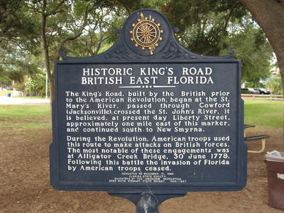
Historic King's Road British East Florida Marker, Jacksonville, Fl.
This marker is located by Friendship Fountain in Jacksonville, Florida to indicate the location of a road built by the British.
The text on the marker reads as :
" The King's Road, built by the British prior to the American Revolution, began at the St. Mary's River, passed through Cowford (Jacksonville), crossed the St. John's River, it is believed, at present day Liberty Street, approximately one mile east of this marker, and continued south to New Smyrna.
During the Revolution, American troops used this route to make attacks on British forces. The most notable of these engagements was at Alligator Creek Bridge, 30 June 1778. Following this battle the invasion of Florida by American troops ceased."
Dedicated by Florida State Society - Daughters of the American Revolution - Anne White Stewart, State Regent 1995-1997
Latitude, Longitude
30.31969167, -81.66073333
Recommended Citation
George Lansing Taylor, Jr. "Historic King's Road British East FL Marker, Jacksonville, FL." (2010). Image Collection. Item#. University of North Florida, Thomas G. Carpenter Library Special Collections and Archives. UNF Digital Commons, https://digitalcommons.unf.edu/historical_architecture_main/3242/
Image Location

Accessibility Statement
This item was created or digitized before April 24, 2027, or is a reproduction of legacy material created before that date. It is preserved in its original, unmodified state specifically for research, reference, or historical recordkeeping. In accordance with the ADA Title II Final Rule, the Library provides accessible versions of archival materials by request. If you are experiencing difficulty accessing the information on the site due to a disability, please submit a request through the following form for assistance.