

Preview
Creation Date
7-25-2010
Description
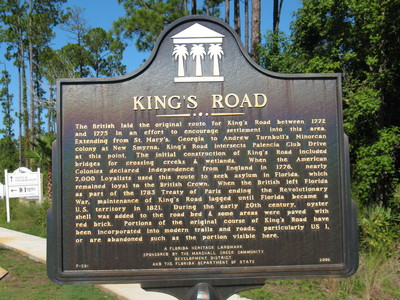
King's Road Marker, St Johns County, FL.
This historical marker about King's Road is located on Palencia Club Drive just east of Highway U.S. 1 in St. Johns County, Florida.
The marker text reads as follows:
"The British laid the original route for King's Road between 1772 and 1775 in an effort to encourage settlement into this area. Extending from St. Mary's, Georgia to Andrew Turnbull's Minorcan colony at New Smyrna, King's Road intersects Palencia Club Drive at this point. The initial construction of King's Road included bridges for crossing creeks & wetlands. When the American Colonies declared independence from England in 1776, nearly 7,000 Loyalists used this route to seek asylum in Florida, which remained loyal to the British Crown. When the British left Florida as part of the 1783 Treaty of Paris ending the Revolutionary War, maintenance of King's Road lagged until Florida became a U.S. territory in 1821. During the early 20th century, oyster shell was added to the road bed & some areas were paved with red brick. Portions of the original course of King's Road have been incorporated into modern trails and roads, particularly U.S. 1, or are abandoned such as the portion visible here. "
The Marshall Creek Community Development District and the Florida Department of State
Latitude, Longitude
30.01301389, -81.39201667
Recommended Citation
George Lansing Taylor, Jr. "King's Road Marker, St. Johns County, FL." (2010). Image Collection. University of North Florida, Thomas G. Carpenter Library Special Collections and Archives. UNF Digital Commons, https://digitalcommons.unf.edu/historical_architecture_main/3295/
Image Location

Accessibility Statement
This item was created or digitized before April 24, 2027, or is a reproduction of legacy material created before that date. It is preserved in its original, unmodified state specifically for research, reference, or historical recordkeeping. In accordance with the ADA Title II Final Rule, the Library provides accessible versions of archival materials by request. If you are experiencing difficulty accessing the information on the site due to a disability, please submit a request through the following form for assistance.