

Preview
Creation Date
7-14-2012
Description
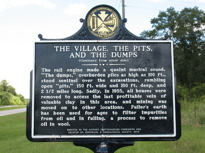
The Village The Pits and The Dumps Marker (Reverse) Amsterdam GA
Continued from other side--- (Side 2)...
" The rail engine made a quaint musical sound. "The Dumps" overburden piles as high as 100 ft., stood sentinel over the excavations, rambling open "pits" 150 ft. wide and 100 ft. deep and 2 1/2 miles long. Sadly, in 1955, all houses were removed to access the last profitable vein of valuable clay in this area and mining was moved to other locations. Fullers earth has been used for ages to filter impurities from oil and in fulling a process to remove oil in wool."
Erected by the Historic Chattahoochee Commission and Decatur Co. Historical & Genealogical Society, 2012.
Latitude, Longitude
30.72691111, -84.43321111
Recommended Citation
George Lansing Taylor, Jr. "The Village The Pits and The Dumps Marker (Reverse) Amsterdam, GA." (2012). Image Collection. University of North Florida, Thomas G. Carpenter Library Special Collections and Archives. UNF Digital Commons, https://digitalcommons.unf.edu/historical_architecture_main/4493/
Image Location

Accessibility Statement
This item was created or digitized before April 24, 2027, or is a reproduction of legacy material created before that date. It is preserved in its original, unmodified state specifically for research, reference, or historical recordkeeping. In accordance with the ADA Title II Final Rule, the Library provides accessible versions of archival materials by request. If you are experiencing difficulty accessing the information on the site due to a disability, please submit a request through the following form for assistance.