

Preview
Creation Date
3-6-2016
Description
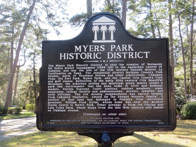
The marker reads: "MYERS PARK HISTORIC DISTRICT The Myers Park Historic District is near the remains of Hernando De Soto’s winter encampment (1539-40) in the Apalachee capital of Anhaica, and was the site of the 17th century Spanish mission La Purificación de Tama. The residential district includes Country Club Estates, parts of Woodland Drives and other subdivisions, Chapman Pond, Old Fort Park, Myers Park, and the Capital City Country Club and golf course. Reflective of the early 20th century City Beautiful Movement, the suburban setting and municipal green spaces create a park-like environment that has been home to civic and business leaders, Florida Supreme Court justices, cabinet members, state employees, college faculty and administrators, doctors, lawyers, and local officials. The low density neighborhood was carved largely from Lakeland Plantation, owned by the Edward Houston family. A portion of that land had belonged to Florida’s first territorial governor, William Pope DuVal, whose home was near the modern tennis courts in Myers Park. Other acreage is from the Flavius and Lula Coles Farm, whose house from the late 19th century still stands on Oakland Avenue. (Continued on other side) F-839 A FLORIDA HERITAGE SITE SPONSORED BY THE CITY OF TALLAHASSEE, THE TALLAHASSEE TRUST FOR HISTORIC PRESERVATION, AND THE FLORIDA DEPARTMENT OF STATE 2014" Top of sign: Florida Heritage emblem
Latitude, Longitude
30 deg 25' 57.17", 84 deg 16' 26.50"
Recommended Citation
George Lansing Taylor, Jr.
Image Location

Accessibility Statement
This item was created or digitized before April 24, 2027, or is a reproduction of legacy material created before that date. It is preserved in its original, unmodified state specifically for research, reference, or historical recordkeeping. In accordance with the ADA Title II Final Rule, the Library provides accessible versions of archival materials by request. If you are experiencing difficulty accessing the information on the site due to a disability, please submit a request through the following form for assistance.